Tahoe Fund

What runs deeper than Lake Tahoe? Our desire to preserve it.

  • About Us
    • Strategic Plan
    • Our Governance
      • Board of Directors
      • Staff
    • Financials
    • Our Founders
    • Stewardship Circle Donors
    • Teens 4 Tahoe
    • Careers
  • Projects
    • Map of Projects
    • Current Projects
      • Caldor Trails Restoration Fund
      • Ski Run Community Park
      • Smartest Forest Fund
      • Tahoe East Shore Trail
      • Taylor Tallac Aquatic Invasive Species Removal
      • Tahoe Fund Endowment
      • Tahoe Trails Endowment
      • Tahoe Regional Trails Plan
      • Take Care Tahoe
      • Environmental Venture Trust
      • Aquatic Invasive Species (AIS)
    • Completed Projects
      • Angora Creek Bridge Replacement
      • Aquatic Invasive Bottom Barrier Challenge
      • ARC Community Leadership
      • Basin Bike Racks
      • Beaver Tail Trail
      • Blackwood Creek and Eagle Rock Trail Restoration
      • California Forest Observatory
      • Camp Wamp Field Trips
      • Clean Up The Lake
      • Desolation Wilderness Trail Restoration
      • Digital Acoustic Owl Monitoring
      • Dollar Creek Bike Path
      • DRINK TAHOE TAP Water Refill Stations
      • Elk Point Marina Bubble Curtain
      • Emerald Bay Asian Clam Control
      • Emerald Fire Restoration
      • Generation Green
      • Homewood On-Water Electric Boat Charging Station
      • Incline Flume Trail
      • Johnson Meadow
      • Lakeside Bike Trail
      • Lake Tahoe Wildlife Care Outdoor Learning Center
      • Lily Lake Trail
      • Loyalton Biomass
      • McConkey Eco-Challenge
      • Mikey Hallenbeck Memorial
      • North Tahoe Boys & Girls Club Mountain Bike Program
      • Peregrine Falcons
      • Rabe Meadow Bike Path
      • Rubicon Trail & Lighthouse Improvements
      • Sand Harbor Beach Improvements
      • Ski Run Aquatic Invasive Weed Removal
      • Sled Corrals
      • Spooner Lake Amphitheater
      • South Tahoe Boys and Girls Club Mountain Biking Program
      • Stories in the Snow
      • Sugar Pine Plantings
      • Sugar Pine Reforestation
      • Tahoe Beaches.Org
      • Tahoe Bike Map
      • Tahoe City Aquatic Invasive Weed Removal
      • Tahoe In Depth
      • Taylor Creek Overlook
      • Taylor Creek Stream Profile Chamber
      • Third Creek and Incline Creek Watershed Restoration
      • Tunnel Creek Singletrack
      • UC Davis State of the Lake Report
      • UV Light Pilot Project
      • Upper Tyrolian Trail
      • Van Sickle Bi-State Park
      • West Shore Bike Path
    • Submit a Project
    • Tahoe Fund Environmental Venture Trust
  • Ways to Give
    • Donate Online
    • Current Projects
    • Join The Stewardship Circle
    • Smartest Forest Fund
    • Planned Giving
    • In Memoriam Donations
    • Tahoe Weddings
    • $1 for Tahoe
    • Corporate Partnerships
  • Events
    • 2021 Lake Tahoe Summit
    • 2021 Founders Circle Dinner
    • 2nd Annual Tahoe Fund Boat Parade
    • Tahoe Fund Talks: California & Nevada’s Commitment to
    • Tahoe Fund Talks: The CARES Act Impact on 2020 Giving
    • Tahoe Fund 10th Anniversary Celebration Boat Parade
    • 2020 Lake Tahoe Summit
    • 2020 Platinum First Tracks at NorthStar
  • PLATES FOR POWDER
  • News
  • Blog
You are here: Home / Our Projects / Completed Projects / Incline Flume Trail

Incline Flume Trail

Partners: USFS, Nevada Land Trust, Friends of Incline Trails, TAMBA, Tahoe Rim Trail Association, NV State Parks
Total Project Cost: $200,000

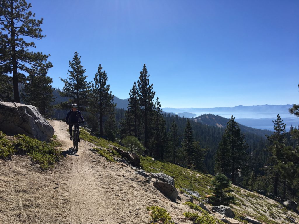
The Incline Flume Trail, known as the “other flume” trail, runs from Mt. Rose Highway to the Tunnel Creek Trail above Incline Village. Its easy and flat terrain makes it the most family-friendly biking and hiking trail in the Basin.

While a well-used trail by many, it was not recognized as an official trail by the Forest Service until recently. In this status, we were unable to add way-finding and interpretive signage, or do much-needed trail reconstruction and maintenance work.  The Tahoe Fund, working with the Friends of Incline Trails, funded and secured the necessary environmental approvals to make it an official Forest Service trail.

This new designation was received in May 2017, paving the way for Tahoe Fund to secure a grant for $130,000 from the Recreation Trails Program that helped improve the trail, build a retaining wall in a particularly erosive area, and install interpretive and way-finding signage. It will also help fund the transfer of the historic bullwheel (located nearby the trail) from the Nevada Land Trust to the US Forest Service.

The restoration work was led by the Friends of Incline Trails in partnership with the Forest Service, the Tahoe Rim Trail Association and the Tahoe Area Mountain Biking Association (TAMBA). More than 2,000 volunteer hours were put into the trail improvements.

In December 2015, David and Cheryl Duffield donated 18.6 acres of land along the trail, including the historic bull wheel, to Nevada Land Trust, a nationally-accredited nonprofit conservation land trust based in Reno whose work includes a portion of the Tahoe Basin. Volunteers from TAMBA, the Tahoe Rim Trail Association, and Friends of Incline Trails built the missing link of the trail through that section of property in Fall 2016, opening the trail from Mt. Rose Highway all the way to the Tunnel Creek Trail. The land will be transferred from the Nevada Land Trust to the Forest Service later this year, putting the entire trail in public hands for the first time in decades.

Major trail improvements were completed in 2018 including much needed way finding signage.


Facebook
fb-share-icon
Twitter
Tweet
LinkedIn
Share

INTERACTIVE MAP

Explore our projects and learn more about how they will help shape the future of Lake Tahoe.

Keep up with our latest news & events by joining our e-newsletter.

  • Contact Us
  • Tahoe Fun Facts
  • News
  • Site Map
  • Terms of Use
  • Privacy Policy

PO Box 7124  |   Tahoe City, CA 96145  |   775.298.0035

Tax ID: 01-0974628