Tahoe Fund

What runs deeper than Lake Tahoe? Our desire to preserve it.

  • About Us
    • Strategic Plan
    • Our Governance
      • Board of Directors
      • Staff
    • Financials
    • Our Founders
    • Stewardship Circle Donors
    • Teens for Tahoe
    • Careers
  • Projects
    • Our Projects
    • Submit a Project
    • Support a Project
      • Aquatic Invasive Species (AIS)
      • Environmental Venture Trust
      • Smartest Forest Fund
      • Tahoe City Bear Plaques
      • Tahoe East Shore Trail
      • Tahoe Trails Endowment
  • Ways to Give
    • Donate Online
    • Current Projects
    • Join The Stewardship Circle
    • Smartest Forest Fund
    • Planned Giving
    • In Memoriam Donations
    • Tahoe Weddings
    • $1 for Tahoe
    • Corporate Partnerships
  • Events
    • Boat Parade
    • Founders Circle Summer Celebration
    • Lake Tahoe Summit
    • TEDxReno Salon: “Crystal Clear: Understanding Tahoe’s Water Clarity”
    • Tahoe Fund Talks
      • Life Beneath Tahoe Waters
      • California & Nevada’s Commitment to Lake Tahoe
      • The CARES Act Impact on 2020 Giving
  • PLATES FOR POWDER
  • News
You are here: Home / Blog

Lake Tahoe Fun Fact: Glacial Lakes

June 10, 2020 by Skyler Monaghan

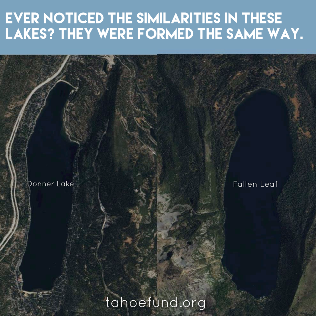
Ever noticed lakes throughout the Tahoe area are similar looking? Thousands of years ago, the world went through glacial periods in which ice plowed down from the mountain tops above and created many of the lakes we love today.

Here is some more information on the formation of three bodies of water formed by glaciers.

Fallen Leaf Lake

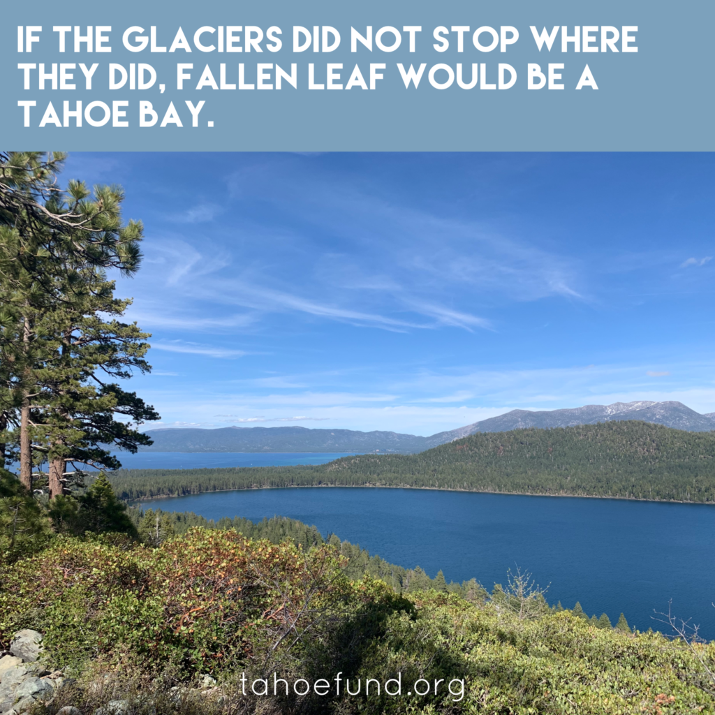
Fallen Leaf Lake is the product of not one, but two glaciers colliding and traveling north down the Glen Alpine Valley and finally coming to a stop before reaching Lake Tahoe. On the northeastern side of the lake a terminal moraine can be seen. Moraines are large deposits of rocks and debris carried down by the glacier. In this case, the moraine signifies the end of the glacier, acting as a natural dam.[1][5]

Emerald Bay

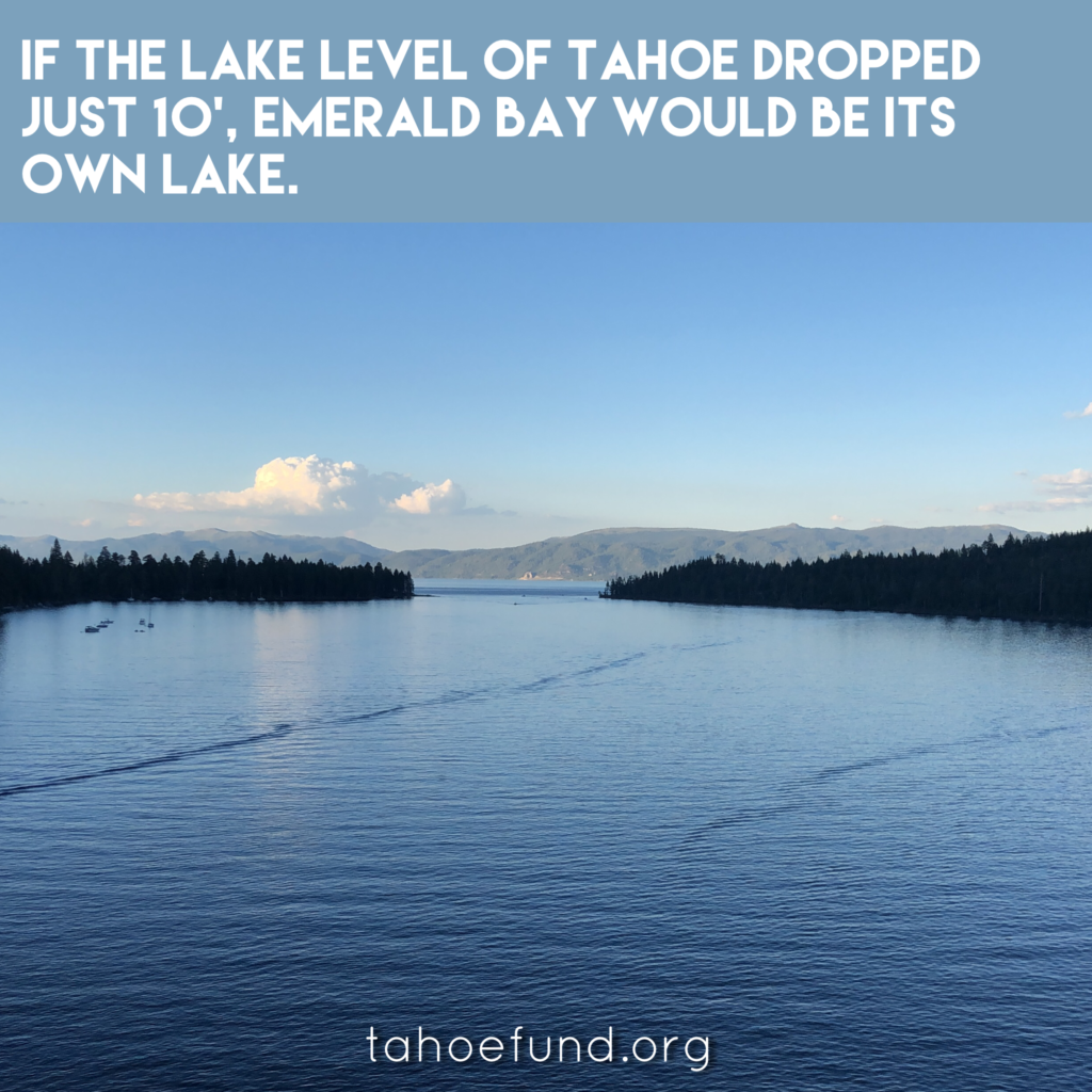
Emerald Bay was formed during the last glacial episode which started about 110,000 years ago and ended about 15,000 years ago.[2] The four-mile-long glacier that contributed to the Emerald Bay formation started on the north slopes of Dicks peak and pushed its way down Eagle Creek moving towards the lake until the two met.[2] When the glacier entered the lake it began to melt, leaving the debris along the lake’s shore creating lateral moraines on the north and south sides and leaving a recessional moraine at the mouth of the bay.

Donner Lake

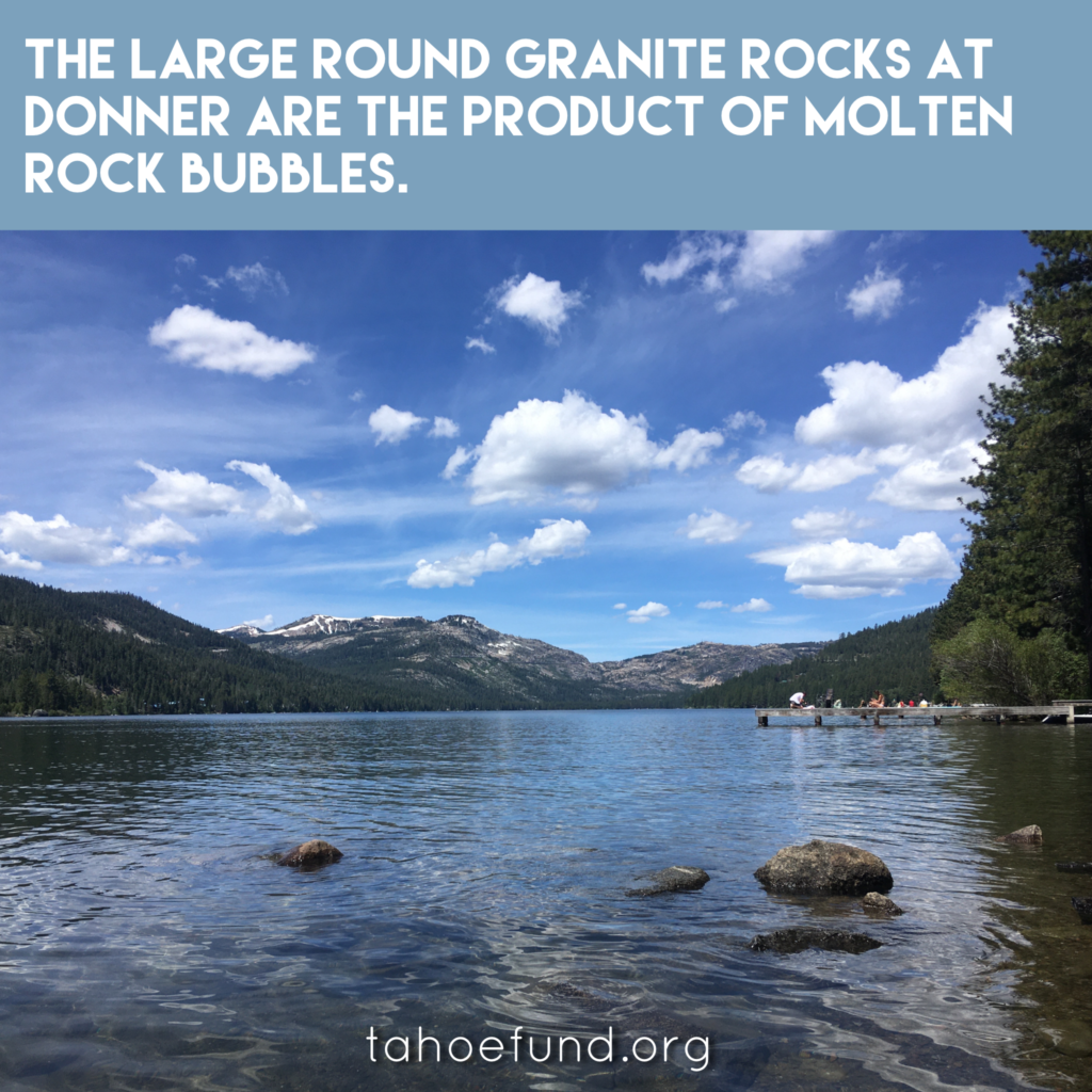
Thousands of years ago, a large glacier flowed down the Eastern Slope of Donner Pass carving a path along a rock fault.[3] As the glacier eventually retreated, it left two lateral moraines on the sides and a terminal moraine of large rocks, gravel and loose soil that blocked the creek resulting in the formation of Donner Lake.[4] For this reason, Donner lake is classified as a moraine-dammed lake. These long, finger-shaped lakes are also referred to as ribbon lakes, which you can see clearly from the pictures of Donner and Fallen Leaf Lake.

Sources:

[1]: “National Snow and Ice Data Center.” All About Glaciers | National Snow and Ice Data Center, 16 Mar. 2020, nsidc.org/cryosphere/glaciers/.

[2]: Fuller, M, et al. “Emerald Bay State Park: National Natural Landmark 1969.” California Parks, California Geological Survey, Department of Conservation, 2015, www.parks.ca.gov/pages/734/files/GeoGem%20Note%2034%20Emerald%20Bay%20State%20Park.pdf.

[3]: “Docent Manual Chapter 5 – AdditionalResources .” Tahoe UC Davis, UC Davis, 2016, tahoe.ucdavis.edu/sites/g/files/dgvnsk4286/files/inline-files/Docent%20Manual%20Chapter%205%20-%20AdditionalResources.pdf.

[4]: “History & Natural History – Donner Memorial State Park.” Sierra State Parks Foundation, sierrastateparks.org/donner-memorial-state-park/history-natural-history/.

[5]: Fallen Leaf Lake

Filed Under: Uncategorized

Award-winning documentary “Wilder than Wild: Fire, Forests, and the Future” to screen virtually through Tahoe Art Haus & Cinema

June 9, 2020 by Skyler Monaghan

LAKE TAHOE, Calif./Nev. (June 9, 2020) – The Tahoe Network of Fire Adapted Communities (Tahoe Network), with generous support from the Tahoe Fund, is hosting a free virtual screening of the award-winning documentary Wilder than Wild: Fire, Forests, and the Future through the Tahoe Art Haus & Cinema from June 5th – June 11th, 2020.

Wilder than Wild is a one-hour documentary that reveals how fire suppression and climate change have exposed Western landscapes to large, high-intensity wildfires. The film goes on to explore strategies that are being developed to help mitigate the impact of these fires.

The screening at Tahoe Art Haus & Cinema is part of a larger effort to engage communities in conversations about the future of wildfire. An online Q&A panel featuring both a local fire district representative and forest management expert will follow the screening on June 11th at 5pm.

The Tahoe Network recognizes the importance of building community awareness about mitigation strategies in this new age of wildfire and strives to prepare people and property for wildfire by coordinating efforts on a neighborhood scale.

“Unfortunately, living in a forest like we do in Tahoe means living with the threat of catastrophic wildfire,” said Tahoe Fund CEO Amy Berry. “We are so excited to make this terrific film available for everyone to watch for free to learn more about the history of wildfire. It is definitely worth an hour of your time.” 

Screening Date: June 5th – June 11th 2020

Screening Location: Online through Tahoe Art Haus & Cinema

Watch the film here.

Register for the Q&A panel here.

This event is open to the public and is free thanks to sponsorship from the Tahoe Fund.

Filed Under: News

Lake Tahoe Fun Fact: 750,000

June 4, 2020 by Skyler Monaghan

Lake Tahoe Fun Fact: 750,000

As a result of forest treatments to help reduce the threat of catastrophic wildfire, there are now more than 750,000 burn piles in the Tahoe Basin waiting to be burned or transported to a mill or biomass facility. With wildfire intensity growing every year, it is important to understand wildfire and how you can be prepared. The Tahoe Fund has partnered with the Tahoe Fire and Fuels Team to bring you a free virtual screening of the film “Wilder Than Wild: Fire, Forests, and the Future” from June 5th through June 11th. Join us for a Q&A session with the director and members of our fire districts at 5pm on June 11th.

Click on the link to access the movie through Tahoe ArtHaus: http://ow.ly/9nC250zYbq3

Filed Under: Uncategorized

Lake Tahoe Fun Facts: 82 Degrees

May 27, 2020 by Skyler Monaghan

It’s warming up! Today’s forecasted high air temperature is 82 degrees. This is only 2 degrees below the previous record of 84 degrees set on May 28, 2003. This data comes from the South Lake Tahoe airport, which has been recording data as an official climate station dating back to May 1,1968. It snowed over a foot this same week last year.

Filed Under: Uncategorized

Tahoe East Shore Trail Extension

May 27, 2020 by Skyler Monaghan

Frequently Asked Questions

Last year we celebrated the opening of the new Tahoe East Shore Trail, a path that received over 1,000 visitors a day in the following months. With unrivaled views, an 810-foot long bridge, and beautiful vista points, it quickly became a highlight for many visitors and residents. The trail has been successful in providing safe access to the east shore with an accessible trail that provides exercise and enjoyment of the Lake to a diverse group of users.

Plans are now underway for the next phase of the Tahoe East Shore Trail, extending from Sand Harbor to Spooner Summit. Project partners at the Tahoe Transportation District, Nevada Department of Transportation, and the US Forest Service, are finalizing the environmental approvals and preliminary construction schedule for the next segment.

This next phase will expand the Highway 28 safety improvements, shared-use path, parking, transit stops, emergency pullouts, visitor amenities, and other environmental improvements.

We know there are a lot of questions about this next section. Here are some answers to the ones we hear the most frequently:

When Will Construction Start on the New Section of the East Shore Trail?

  • Unfortunately, Covid-19 delayed many grant requests. Right now the agencies are hoping to begin construction on the new parking lots and next new section of the path in 2023. Construction will likely take place over 5-7 construction seasons, ending in 2030.

Is IVGID’s Effluent Pipeline Replacement Part of the Project?

  • It is unclear at this time. If the IVGID Board of Trustees approves and if timing aligns, the environmental analysis would allow the co-location of IVGID’s pipeline replacement. IVGID’s current pipeline runs under Highway 28 and in some area is more than 50 years old. It often requires emergency maintenance that is expensive and requires closure of Highway 28. Doing the projects together should save on construction timing and costs.
  • The new pipeline will run in conjunction with the path for the majority of the alignment, transporting treated wastewater from the District’s water resource recovery facility to the disposal point at the wetlands in the East Carson Valley.  The project partners have developed project timelines that match IVGID’s priorities for replacement of the pipeline.

What About Parking?

  • In addition to the 91 parking spots now at the North end of the trail, the Tahoe Transportation District received funding from the Tahoe Fund and public sources to complete approximately 90 additional parking spaces along Highway 28 in Incline Village. Construction is scheduled to begin in 2023.
  • The current parking at Secret Harbor and Chimney Beach will be expanded with approximately 105 and 140 new spaces respectively. Construction is estimated to take place in 2024.
  • The US Forest Service also plans also include a new parking lot at Skunk Harbor with an estimated 40 new parking spaces.  Construction is timing is based on future funding availability.
  • There are plans for a new parking lot across from the Spooner Lake State Park entrance that will hold approximately 250 vehicles.
  • In total, there will be approximately 535 new parking spaces in the corridor from Sand Harbor to Spooner Summit. During peak periods, there are currently more cars parking on the shoulder than the amount of spaces that can be provided due to the physical constraints within the corridor. The plan is to provide transit stops at each of these locations to fill the gap during peak periods. This is to meet existing visitor recreation access and not to encourage greater access to the beaches and coves.

How Long Will the New Section of Trail Be?

  • The new section of the East Shore Trail will run from Sand Harbor to Spooner Summit and will be 8 miles long. Adding to the existing 3 miles of trail that currently runs from Incline to Sand Harbor, the trail will be a total of 11 miles when complete.
  • The new section of the trail from Sand Harbor to Spooner Summit will be on the lake side of the highway and will follow the route of the highway and not the edge of the shoreline.

What About the Boat Inspection Station at Spooner Summit?

  • The project will provide a permanent Aquatic Invasive Species boat inspection station location near Hwy 50.

Will There be Donor Recognition Opportunities?

  • In short, you bet!
  • The new section of the path will feature more trout, more bears, and more vista points, giving donors the opportunity to once again leave their legacy on the trail in a unique and inspirational way.
  • Tahoe Fund will announce new vista point opportunities in 2023. If you are interested in reserving a vista, please email Karolina at khedman@tahoefund.org.

What About the Next Sections of the Trail?

  • The goal is to one day circumnavigate Lake Tahoe with the Tahoe Trail. As of today, 35 miles are complete.
  • On the Nevada side, the Tahoe Transportation District is working at both the north and south ends of the Nevada section. On the south end, the Tahoe Transportation District is working on a ½ mile connection from the casino resort core to the existing Rabe Meadow trail,  as well as a 3 mile extension of the trail from the U.S. Forest Service’s Round Hill Pines Historic Resort north to the Zephyr Cove Resort & Beach.
  • In addition, on the north end the Tahoe Transportation District is currently seeking grant funding to complete the 3 mile segment from Crystal Bay to Incline Village. The Environmental Analysis and 30% preliminary engineering for this segment of trail is planned to begin in 2021. As with all aspects of the trail plans, the impacts of Covid-19 may delay Tahoe Transportation District’s ability to access grant funds.   
  • The Tahoe Trail continues to be a lakewide effort involving many interests and jurisdictions around the Tahoe Basin.

How Can I Find out More?

Recently the US Forest Service released the Environmental Assessment on the proposed section of trail from Sand Harbor to Spooner Lake. You can also visit Tahoe Transportation District website at www.tahoetransportation.org

Filed Under: Uncategorized

  • « Previous Page
  • 1
  • …
  • 40
  • 41
  • 42
  • 43
  • 44
  • …
  • 81
  • Next Page »

INTERACTIVE MAP

Explore our projects and learn more about how they will help shape the future of Lake Tahoe.

Keep up with our latest news & events by joining our e-newsletter.

Categories

  • $1 for Tahoe
  • Archive
  • Events
  • News
  • Contact Us
  • Tahoe Fun Facts
  • News
  • Site Map
  • Terms of Use
  • Privacy Policy

PO Box 7124  |   Tahoe City, CA 96145  |   775.298.0035

Tax ID: 01-0974628
Lake Tahoe Destination Stewardship Council